Odisha is located on the eastern coast of India, bordered by the Bay of Bengal to its east and southeast. Today, it stands as a popular destination for tourists, known for its rich cultural heritage and natural beauty. Odisha is the ninth largest state in India by area and ranks eleventh in terms of population.
Table of Contents
Location and Extent of Odisha
- Odisha is geographically situated between latitudes 17°49’N and 22°34’N and longitudes 81°27’E and 87°29’E. Its capital city, Bhubaneswar, often referred to as the “Cathedral City” or “Temple City,” is renowned for its ancient temples and architectural heritage.
- Covering an area of 1,55,707 square kilometers, Odisha accounts for approximately 4.73% of India’s total landmass, making it one of the larger states in the country.
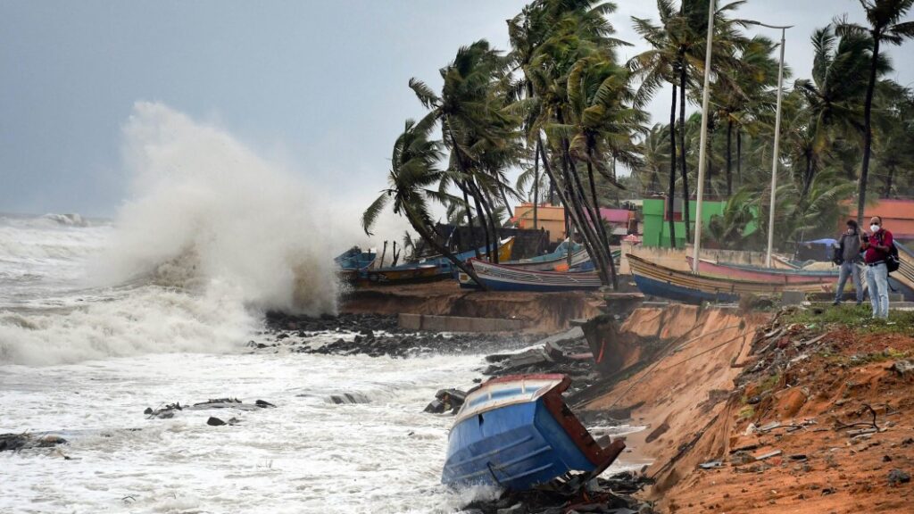
- The state boasts a coastline of around 450 kilometers, stretching from Ichchapuram in the south to the Subarnarekha River in the northeast. This extensive coastal boundary is dotted with scenic beaches and serves as a key region for marine biodiversity and tourism.
- Odisha’s landmass bulges outward, extending from Brahmagiri near the Chilika Lake in the southwest to Chandabali in the northeast, giving the state its distinctive geographical shape.
- It ranks as the ninth-largest state in India in terms of area and the eleventh most populous state, with a diverse population spread across its rural and urban landscapes. This combination of geographical size and population density adds to Odisha’s economic and cultural significance within India.
Boundaries of Odisha
- Odisha is one of India’s 28 states, situated on the eastern coast of the country.
- It is bordered by Jharkhand to the north, West Bengal to the northeast, the Bay of Bengal to the east, Andhra Pradesh to the south, and Chhattisgarh to the west and northwest.
Physiographic Region of Odisha
Based on homogeneity, continuity, and physiographical features, Odisha is divided into five distinct morphological regions:
- The Odisha Coastal Plains in the east
- The Middle Mountainous and Highlands Region
- The Central Plateaus
- The Western Rolling Uplands
- The River Valleys and Floodplains
The Odisha Coastal Plains in the East
The coastal plains of Odisha are depositional landforms of recent origin, geologically belonging to the Post-Tertiary period. They extend along the eastern coast of India, from the Subarnarekha River in the northeast to the Rushikulya River in the southwest. The plains are bounded to the west by the 75-meter contour, which separates them from the middle mountainous region. Fertile and agriculturally productive, this area is known as the “Rice Bowl of Odisha.” The coastal plain is narrow in the north, widest in the middle, narrowest near Chilika Lake, and broadens again in the south. This region is often referred to as the Hexadeltaic region or the “Gift of Six Rivers,” fed by the Subarnarekha, Budhabalanga, Baitarani, Brahmani, Mahanadi, and Rushikulya rivers.
The coastal plains of Odisha are divided into three sub-regions:
- Northern Coastal Plains (Balasore Plains): This region includes the floodplains and deltas of the Subarnarekha and Budhabalanga rivers up to the Baitarani River. It is one of the worst drought-affected areas of Odisha, despite being crisscrossed by rivers.
- Middle Coastal Plains (Cuttack-Puri Coastal Plain): Located between the northern and southern coastal plains, this region encompasses the combined deltas of the Salandi, Baitarani, Brahmani, and Mahanadi rivers. The Mahanadi delta, located here, is the widest in the state.
- Southern Coastal Plains (Rushikulya Plains): This region is dominated by the fluvial deposits of the Rushikulya River and includes the lacustrine plains of Chilika Lake, as well as smaller deltas formed by the Rushikulya River.
The Coastal plains are further divided into three parallel zones along the shoreline:
- The Salt Tract: A narrow belt stretching 4.8 to 9.6 km inland from the coast, this area is covered with tidal forests and is filled with salt, making it unsuitable for agriculture. The sluggish, brackish streams create a challenging landscape. In the Mahanadi delta, this region is known as the “Little Sunderbans” due to its dense tidal forests.
- The Arable Tract: Known as the “rice country,” this fertile central zone is the richest agricultural area in Odisha. It features levees (embankments to prevent river overflow), but during floods, large swathes of land are submerged, impacting both human and animal life.
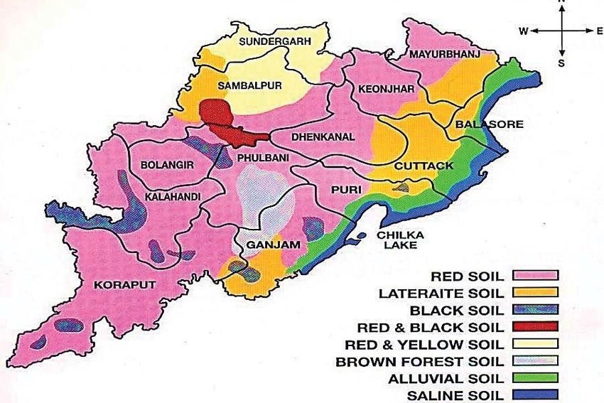
- The Sub-Montane Tract: Located to the west of the plains, this zone is where the arable lands meet the spurs of the Eastern Ghats. It is characterized by red soil and low levels of laterite soil, making it prone to soil erosion. The region supports natural vegetation ranging from thorny shrubs to sal forests, marking it as a transition zone.
The Middle Mountainous and Highlands Region
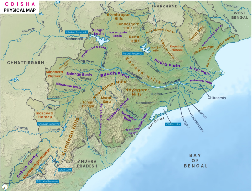
This region encompasses roughly three-fourths of the entire state of Odisha, with elevations ranging from 610 to 1,068 meters above sea level. It forms part of Peninsular India and is primarily composed of hills and mountains belonging to the Eastern Ghats. These mountains rise abruptly in the east and gently slope towards a dissected plateau in the west, creating a series of watersheds. Stretching from the northeast (Mayurbhanj) to the northwest (Malkangiri), the Eastern Ghats are interrupted by both broad and narrow river valleys, along with floodplains.
The major rivers of Odisha—Baitarani, Brahmani, Mahanadi, Rushikulya, Vamsadhara, and Nagavali—along with their tributaries, have carved deep, narrow valleys into this mountainous region. Morphologically, the middle mountainous region can be divided into the following sub-regions:
- Simlipal and Meghasani Mountains: These volcanic mountains are dome-shaped with circular structures, with elevations ranging from 600 to 1,050 meters. The two significant peaks in this area are Simlipal (900 m) and Meghasani (1,147 m).
- Mankadnacha, Malayagiri, and Gandhamardan Mountains (Baitarani-Brahmani Interfluves): This group of peaks runs in a north-south direction, with Malayagiri, Mankadnacha, and Gandhamardan rising to 1,170 m, 1,092 m, and 1,044 m, respectively. These mountains are part of the Eastern Ghats and represent a poly-cyclic region, shaped by multiple cycles of erosion.
- Watershed between the Brahmani and Mahanadi Rivers: Similar in origin to the Baitarani-Brahmani interfluves, these mountains have been significantly dissected due to the continuous action of the Mahanadi and Brahmani rivers. The range runs northwest in the northern portion and shifts to a north-northwest to south-southwest direction in the southern portion.
- Interfluves of the Mahanadi, Rushikulya, and Vamsadhara Rivers: This deeply eroded watershed runs in a north-south direction, with elevations ranging from 600 to 1,000 meters. The region is home to many peaks exceeding 1,200 meters, including Singaraju (above 1,500 m), Mahendragiri (above 1,500 m), and Devagiri (1,360 m).
- Potangi and Chandragiri Mountain Ranges: These mountains are among the highest in Odisha, separating the Sabari basin from the Nagavali River. The terrain here is highly dissected, with elevations ranging from 900 to 1,350 meters. The highest peak in Odisha, Deomali (1,672 m), is located in this range, in the Koraput district. Other prominent peaks include Galikonda (1,643 m), Sinkaram (1,620 m), and Turiakonda (1,598 m). While the hilltops are largely barren due to shifting cultivation practices, farmers engage in terrace farming in the valleys.
This rugged and elevated terrain plays a crucial role in shaping Odisha’s climate, water resources, and agricultural practices.
The Central Plateaus
These plateaus are located on the western slopes of the Eastern Ghats and have been largely eroded over time. Their elevation ranges from 305 to 610 meters. Odisha has two main plateaus:
- Panposh-Keonjhar-Pallahara Plateau (Upper Baitarani Catchment Basin): This plateau is bordered by the Singhbhum and Ranchi plateaus to the north, the Simlipal Mountains to the east, and the Mankadnacha Mountains to the west. The Baitarani River is the primary river draining this region, which experiences high rainfall during both the monsoon and winter seasons.
- Nabarangpur-Jeypore Plateau (Upper Sabari Basin): The Bastar Mountains form the western boundary of this plateau, while the Chandragiri and Potangi mountains lie to its east. The Sabari River, along with its tributaries, drains this area, which receives more than 178 cm of rainfall annually, making it the region with the highest rainfall in the state. This abundant rainfall supports the cultivation of fine-quality rice.
The Western Rolling Uplands
These uplands are lower in elevation compared to the plateaus, ranging from 153 to 305 meters. The Western rolling uplands are divided into the following morphological units:
- Rajgangpur-Panposh uplands: Drained by the Koel and Sankh rivers.
- Jharsuguda uplands: Located in the Ib basin.
- Baragarh uplands: Situated within the Jira and Jhaun basins.
- Balangir-Titilagarh-Patnagarh uplands: Part of the northern Tel basin.
- Bhawanipatna uplands: Found in the southern Tel basin.
- Malkangiri uplands: Located in the Sabari basin.
The River Valleys and Flood Plains
These river valleys are shaped by the fluvial action of Odisha’s major rivers. The average elevation of the river valleys and floodplains ranges from 75 to 150 meters. In the upper reaches, the valleys are narrow and deep, becoming slightly wider in the middle, and reaching their broadest point in the lower stretches, where they merge with the plains. Key river valleys in the state include:
- The Mahanadi River Valley
- The Brahmani River Valley
- The Vamsadhara River Valley
The floodplains within these valleys are highly fertile, making them crucial for agriculture. Much of the state’s farming activity takes place on these fertile floodplains, formed by the rivers.