The drainage system of Odisha, located in the eastern part of India, plays a crucial role in shaping the state’s landscape, economy, and ecology. Odisha’s rivers, which primarily originate from the Eastern Ghats, flow eastward into the Bay of Bengal, creating a complex network of watercourses. Major rivers like the Mahanadi, Brahmani, Baitarani, and Subarnarekha, along with their tributaries, form the backbone of this system. These rivers not only support agriculture and provide water for drinking and industrial purposes but also play a key role in the state’s flood control mechanisms. Odisha’s diverse topography, ranging from coastal plains to hilly terrains, influences the flow and behavior of its rivers, which in turn affect irrigation, soil fertility, and flood risks. An understanding of Odisha’s drainage system is essential for sustainable water management, disaster mitigation, and the development of the region’s vast natural resources.
Table of Contents
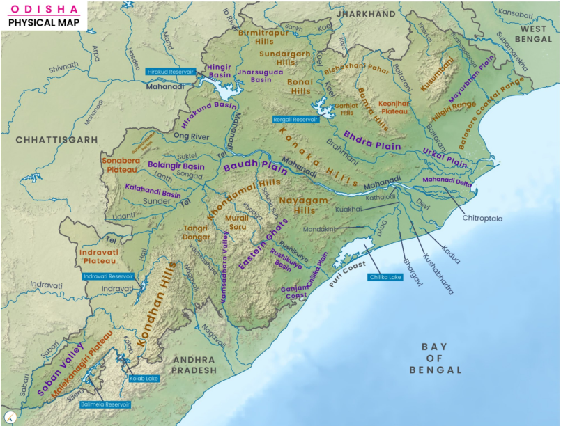
Rivers System of Odisha
Odisha is home to several significant rivers that ultimately flow into the Bay of Bengal. These rivers are categorized into six groups based on their sources of origin:
- Chota Nagpur Plateau: Includes the Subarnarekha and Brahmani rivers.
- Amarkantak Plateau: Source of the Mahanadi River.
- Mahanadi Delta: Includes rivers like the Soamoli, Gobari, Prachi, Kadua, Dhanua, Ratnachira, and Nuna.
- Keonjhar Plateau: Source of the Baitarani River.
- Eastern Slopes of the Eastern Ghats: Includes the Budhabalanga, Rushikulya, and Salandi rivers.
- Other Rivers from the Eastern Ghats: Includes the Bahuda, Nagavali, Vamsadhara, and rivers associated with the Godavari system.
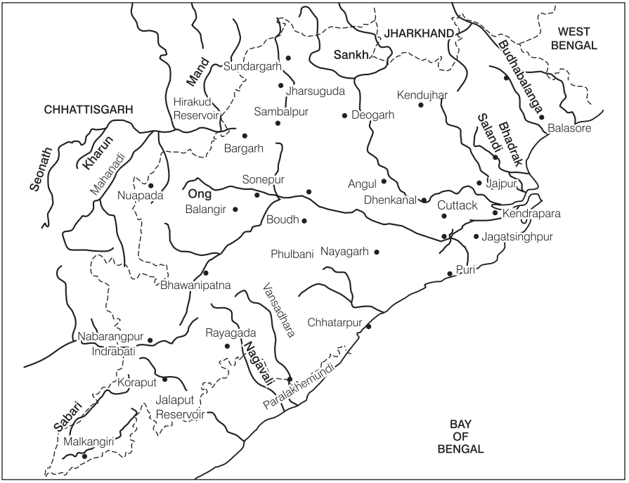
Rivers of Chota Nagpur Plateau
The rivers originating from the Chota Nagpur Plateau are:
Subarnarekha River
- Originates from the southern slopes of the Chota Nagpur Plateau in Bihar.
- The river spans a total length of 433 km, with 70 km flowing through Odisha.
- Its total catchment area is 19,500 sq km, out of which 3,200 sq km lies in Odisha.
- The Subarnarekha is the second-largest river in Odisha, flowing through the states of Jharkhand, Odisha, and West Bengal.
- In Odisha, it forms the boundary with West Bengal, entering at Lakshmannath (north-east of Jaleshwar), and eventually drains into the Bay of Bengal.
- It passes through the districts of Mayurbhanj and Balasore in Odisha.
- Key tributaries include the right bank tributaries: Kanchi, Karkari, Kharkai (the longest), Raru, Garru, and the left bank tributary Dulang.
Brahmani River
- Formed by the confluence of two smaller rivers, Sankh (right bank) and Koel (left bank), near Vedvyasa in Sundargarh district, Odisha.
- Originates from the southern slopes of the Chota Nagpur Plateau in Bihar and flows through Jharkhand and Odisha.
- The river spans a total length of 799 km, with 480 km flowing through Odisha.
- Its total catchment area is 39,055 sq km, with a significant portion located in Odisha.
- The river forms a minor gorge at Rengali and runs a north-south course from Rourkela to Talcher.
- At Rengali, south of Barkot, its waters are used for irrigation and hydel power generation.
- Brahmani passes through the districts of Sundargarh, Angul, Dhenkanal, Deogarh, Jajapur, Kendrapara, and Cuttack in Odisha.
- It shares a common flood outlet with the Mahanadi River through Maipura, contributing to the formation of the Wheeler Islands before discharging into the Bay of Bengal near Dhamra.
- Key tributaries include right bank tributaries such as Sankh, Gohira, Lingarajara, Tikra, Singda, Nandia, and left bank tributaries such as Birupa, Ramial, Samakoi, Mankada, and Kurali.
River of Amarkantak Plateau
Mahanadi River
- The Mahanadi originates from the Amarkantak Hills of the Bastar Plateau in Raipur district, Chhattisgarh.
- The river stretches over a total length of 858 km, with 494 km flowing through Odisha.
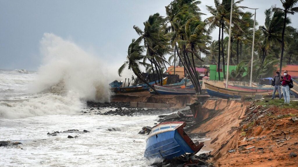
- Often referred to as the “Sorrow of Odisha” due to its frequent flooding, the river’s catchment area in Odisha covers 65,580 sq km.
- It is the largest river in Odisha and the sixth-largest in India, flowing through Chhattisgarh and entering Odisha near Padigan. The Hirakud Dam, the longest in the world, is built on the Mahanadi.
- From Sambalpur to Sonepur, the Mahanadi follows a north-south course, and several right-bank tributaries, including the Jira and Jhaun rivers, meet it, draining the Baragarh plain.
- The Tel River, the Mahanadi’s largest tributary, joins it on the right bank at Sonepur.
- The river flows through the districts of Sambalpur, Sonepur, and Cuttack, and cities such as Bhubaneswar, Subalaya, Kantilo, Boudh, and Banki. Before entering Cuttack, it forms a distributary called the Kathajodi River.
- Between Boudh and Banki, the Mahanadi cuts through the Eastern Ghats, forming a gorge at Satkosia.
- The river reaches the plains at Naraj in the Cuttack district, where it meets the old shoreline of the Bay of Bengal and forms a delta.
- The Mahanadi empties into the Bay of Bengal near Jagatsinghpur. Its important right-bank tributaries include the Silari, Sondur, Jonk, Sukha, Kharkhara, and Brutanga rivers, while its left-bank tributaries are the Chhinar, Seonath, Hasdeo, Son, Mand, Kelo, Surli, and Bhidan rivers.
- Most of these rivers, along with the Mahanadi, drain into the Bay of Bengal, except for the Daya and Bhargavi rivers, which flow into Chilika Lake.
Rivers of Mahanadi Delta
Several rivers originate from the Mahanadi delta, serving as distributaries of the Mahanadi River. These rivers are:
- Soamoli River: Originates from Hirapur village and flows into the Bay of Bengal.
- Gobari River: Begins at Devidola and is also known as the Gobardhana River.
- Prachi River: Starts from the Kuakhai River and flows through Phulnakhara, draining the area between the Kandal and Kushabhadra rivers.
- Kadua River: Drains the region between the Prachi and Kushabhadra rivers.
- Dhanua River: A small river originating from Balipatna.
- Ratnachira River: Begins near Mukundapur village and flows into the Bhargavi River.
- Nuna River: Starts near the Ghoradia hills and drains into the Daya River near Sahupara.
River of Keonjhar Plateau
Baitarani River
- The Baitarani River originates from the Gonasika or Guptaganga Hills in the Mayurbhanj district of Odisha and is an eastward-flowing river in Peninsular India.
- Initially, it serves as a boundary between Odisha and Jharkhand.
- The river has a total length of 365 km and a catchment area of 12,190 sq km.
- It initially flows northward before abruptly changing direction by 90 degrees to flow eastward.
- The river passes through the districts of Keonjhar, Mayurbhanj, Sundargarh, Bhadrak, Jajpur, and Kendrapara in Odisha.
- Key tributaries include the Salandi and Matai rivers, along with others such as Kangira, Ardei, Khairi, Bhandan, Deo, Kanjhari, Sita, Musal, and Kusei.
- The Baitarani merges with the Brahmani River at Dhamra in Bhadrak district before emptying into the Bay of Bengal.
Rivers of Eastern Slopes of Eastern Ghats
Budhabalanga River
- The Budhabalanga River originates from the Simlipal Massif, a compact group of mountains, located south of Simlipal Garh in Mayurbhanj district, Odisha. The river stretches for 175 km.
- It has a catchment area of 4,840 sq km, and ancient Paleolithic and Neolithic sites can be found in its valley.
- The river flows through the districts of Mayurbhanj and Balasore in Odisha. Key tributaries include the Sanjo, Deo, Kalo, Sone, Palpala, Katra, and Gangadhar rivers.
- The Budhabalanga River drains into the Bay of Bengal along the Balasore coast, just north of Chandipur.
Rushikulya River
- The Rushikulya River originates from the Rushimal Mountain in Kandhamal district, Odisha.
- The river spans a length of 165 km with a catchment area of approximately 8,963 sq km.
- It flows through the cities of Berhampur, Chhatrapur, Asika, Bhanjanagar, and Sarada, covering much of Ganjam district as it flows southeast.
- Known as the lifeline of Ganjam district, the Rushikulya River lacks a delta at its mouth and features a pear-shaped basin with a well-developed dendritic tributary system.
- Major tributaries include the right-bank tributaries Padma and Ghodahada, and the left-bank tributaries Baghua and Dhanei.
- The river eventually drains into the Bay of Bengal via Chhatrapur block.
Salandi River
- The Salandi River originates from the southern slopes of the Simlipal Massif at Meghasani Mountain in Keonjhar district, Odisha.
- The river spans a length of 144 km with a catchment area of 1,790 sq km, flowing through Bhadrak district.
- A tributary of the Baitarani River, the Salandi discharges its waters into the Baitarani a few kilometers upstream of Chandbali, rather than directly into the Bay of Bengal.
- The Salandi Dam, part of the Salandi Project, is built on the river, providing irrigation to the surrounding regions.
Other Rivers of Eastern Ghats
Bahuda River
- The Bahuda River originates from the Singharaj Hills in the Eastern Ghats, located in Gajapati district of Odisha. It has a total length of 96 km.
- The river flows northeast for 55 km, then southeast for 17 km in Odisha before entering Andhra Pradesh, where it flows for another 18 km.
- It then turns northeast again for 6 km within Odisha before emptying into the Bay of Bengal near Sunapurapeta village.
- Key tributaries of the Bahuda River include Poichandia, Bogiriadi, Batrada Nalla, and Kantajura Nalla.
Nagavali River
- The Nagavali River originates from the eastern slopes of the Eastern Ghats near Lakhbahal in Kalahandi district, Odisha. It is also known as the Langulya River.
- The river is 256 km long, with 161 km of its course in Odisha. Its catchment area in Odisha is about 4,500 sq km.
- The Nagavali flows through Vizianagaram and Srikakulam before draining into the Bay of Bengal near Mofaz Bandar.
- Important tributaries include Pitadar, Satnala, Barha, Srikona Nadi, Vegavati, Baldiya Nadi, Jhanjavathi, Sitagurha, Gumudugedda, and Vonigedda.
Vamsadhara River
- The Vamsadhara River originates from the Niyamagiri Hills in Kalahandi district, Odisha. It stretches for 230 km, with 150 km within Odisha.
- The catchment area of the river in Odisha is about 8,960 sq km. The Vamsadhara is a major east-flowing river located between the Mahanadi and Godavari rivers, traversing Southern Odisha and Northeastern Andhra Pradesh.
- After flowing 150 km, the river enters Andhra Pradesh, passing through Paralakhemundi, Gunupur, Kashinagar, and Bissam Cuttack in Odisha.
- The Vamsadhara eventually drains into the Bay of Bengal at Kalingapatnam, Andhra Pradesh. Important right-bank tributaries include Poladi, Bhangi, and Pedagoda, while left-bank tributaries are Badanalla, Chauladhua, Pandaka Nalla, Badajhar, Harbhangi, Sananadi, and Mahendratanaya.
Godavari System
- The Godavari system includes several tributaries of the Godavari River such as the Indravati, Kolab, Machkund, and Sileru rivers.
Indravati River
- The Indravati River originates from a small rivulet in the Dandakaranya range of the Eastern Ghats in Kalahandi district, Odisha. It spans 530 km in total, with 167 km flowing through Odisha.
- The river’s catchment area in Odisha is 7,400 sq km. It flows southeast and then westward through the Kalahandi, Nabarangpur, and Koraput districts, forming the boundary between Odisha and Chhattisgarh before entering Bastar district in Chhattisgarh.
- Key left-bank tributaries include Keshadhara Nalla, Kandabindha Nalla, Chandragiri Nalla, Golagarh Nalla, Poragarh Nalla, Kapur Nalla, Muran River, Bangiri Nalla, and Telengi Nalla. Right-bank tributaries are Narangi Gudar, Nimbra, Kotri, Bhaskel, and Bandia rivers.
Kolab River
- The Kolab River originates from the Sinkaran Hills in the Eastern Ghats, Koraput district, Odisha. It is approximately 270 km long in Odisha, with a catchment area of about 10,300 sq km.
- The Kolab Dam, part of the Upper Kolab Hydro Electric Project, is built on the river. It eventually merges with the Godavari River in Andhra Pradesh.
- Key tributaries include Karandi Nalla, Guradi Nalla, Kangar Nalla, Garia, Dharmageda Nalla, Jamnadi, Jalengar, Mulervagu Nalla, and Potteru Vagu Nalla.
Machkund (Sileru) Rivers
- The Machkund River originates in the Eastern Ghats in northeastern Andhra Pradesh and flows northwards into the Jalaput Reservoir at the Odisha-Andhra Pradesh border.
- Below the reservoir, the river is known as the Sileru River. It then bends southwest, flowing through southwestern Odisha and eventually joining the Sabari River at Motu, the southwesternmost point of Odisha.
- Hydroelectric dams at the Jalaput Reservoir and along the upper and lower courses of the Sileru provide significant power to the region. The Balimela Reservoir is also used for hydropower generation on the Sileru River.
Conclusion
The drainage system of Odisha is a complex and diverse network of rivers and tributaries that plays a crucial role in the state’s geography and ecology. Originating from various plateaus and hill ranges, these rivers traverse through different districts, contributing to the state’s hydrology and agricultural landscape.
From the eastward-flowing rivers such as the Mahanadi, which is pivotal for its irrigation and hydropower potential, to the north-eastern rivers like the Rushikulya and the Nagavali that sustain the regions they flow through, Odisha’s rivers shape the region’s environmental and economic fabric. The state’s river system includes both major rivers and their tributaries, such as the Brahmani, Baitarani, and Vamsadhara, each contributing uniquely to the region’s water resources.
The diverse river systems not only support agricultural activities but also foster biodiversity and contribute to the local culture and economy. However, the frequent flooding, as observed with rivers like the Mahanadi, underscores the challenges faced by the state in managing these vital water resources effectively.
Understanding and managing the drainage system of Odisha is essential for sustainable development, flood management, and ecological preservation. As Odisha continues to grow and develop, the careful management of its rivers and their catchment areas will remain pivotal in ensuring the region’s environmental and economic resilience.